Morning view from our balcony at the Lodge at Mount Magazine State Park, near Paris, Arkansas. You can see our balcony, then the walkway along the top of the bluff, then the trees along the bluff (right after that, unseen from this angle, is a sheer cliff drop of about a thousand feet), then the river valley below with farms and woodlands, then the Petit Jean river in the valley (the right half is shrouded in fog), then the mountains on the other side of the valley. The photos don't really do it justice....

A view from inside our room, showing the beautiful scenery right off our balcony.

A view of the main lobby sitting area. Last night we were the only ones there. They told us to make ourselves at home, so we did -- we fell asleep while trying to read. Too much fresh air, I guess.

The Lodge at Mount Magazine. They built it right -- all rooms overlook the river valley (none overlook the parking lot on the other side). Our roon was the second balcony in from this end on the top floor.

Here I am on what looks like a grassy knob overlooking the Petit Jean river valley. That's true enough, but if you really look close, just behind the pine tree above my right shoulder, you will see a little piece of something red on a skinny pole. That's a wind sock, and I'm squatting on the hang-glider "launch pad" in the Park. What looks like a fairly gentle slope downward in the left part of this photo is actually a near sheer dropoff several hundred (maybe a thousand?) feet down to the river valley. I can't imagine anyone intentionally jumping off this perch, whether or not attached to a hang glider. A sign nearby says "Hang gliders must register at the Visitor Center" -- I think that's so they can notify the next of kin.

Here's an unnecesary sign. It's at one of the many scenic overlooks along the roads in Mount Magazine State Park.

Here's Cathy, halfway along the right side of the photo, trying to decide what to order for lunch at Stoby's, a restaurant built inside an old railroad car, in downtown Russellville, Arkansas.

A statue in Dardenelle, Arkansas. The enscription reads: "To the Confederate soldiers of Yell County, in appeciation of their splendid valor alnd loyalty, this monument is erected." It's not acceptable anymore (if it ever really was) to display the traditional "Stars and Bars" Confederate flag. So we often saw the version flying here, which has the correct number of stars (eleven) representing the good ol' Confederate States of America. Really, who do they think they're fooling? It's still a Confederate flag, just revamped for the illusion of political correctness.

A very old and famous tree, the Council Oak, on the southern shore of the Arkansas River, in Dardenelle, Arkansas. A plaque reads: "Upon this spot, under the Council Oak, acting Governor Robert Crittenden, and Chief Black Fox, tribe spokesman, met in council, April 1820, and made the treaty which gave to Arkansas all the Cherokee land south of the Arkansas River." I hope I look that good and strong when I am at least 190 years old.

Along the Cedar Falls Trail in Petit Jean State Park, near Dardenelle, Arkansas.

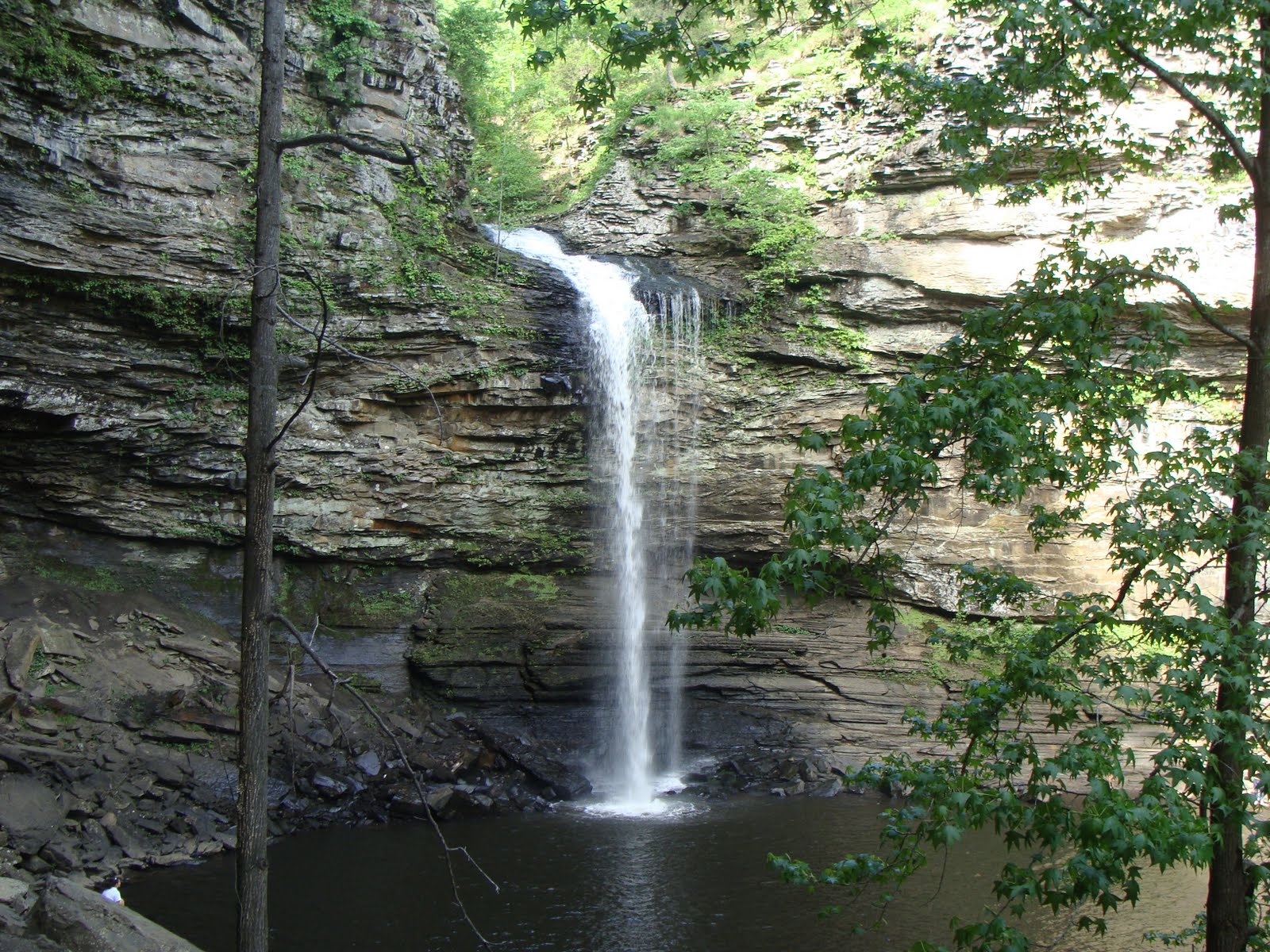
After an hour of fairly strenuous hiking, including hundreds of steps carved out of the canyon wall by the CCC back in the Great Depression, we arrive at the spectacular Cedar Falls, 95 feet high, as seen from the floor of the canyon formed by Cedar Creek.
After hiking back out of the canyon, we had dinner at he Mather Lodge in Petit Jean State Park. Here is a view from the dining room. Barely visible in the haze on the horizon is Mount Magazine, where we spent last night.

Here is the Cedar Falls Overlook. This will give us a different perspective of the falls than that seen two photos ago. Here we will see the falls from above and on the opposite side of the canyon.

Walking out to the far railing on the Overlook shown in the photo above, we took this photo looking down (waaaaay down!) to the Falls below. This gives you a real appreciation for how far down in the canyon we were when we took the earlier photo!

It's worth another view...

Two overlooks of Cedar Falls, each on opposite sides of the canyon. The one in the foreground, the "CCC Overlook," is probably closed. We say "probably" because the next day, when we asked the Park Ranger about it, he claimed to not know it existed (and although it's marked on the map, it is no longer marked on the trail, and it's not easy to find). It looked too flimsy to stand on, so we didn't dare. The other overlook, between the trees in the center top of the photo, is the one from which we took the photos shown above.

I took this photo from the back of Rock House Cave, looking out. (Cathy is looking in, taking a photo of me.) By this time it was beginning to get dark and Cathy was too scared to enter the cave.

The sun sets behind Mount Magazine far off on the horizon.

No comments:
Post a Comment